

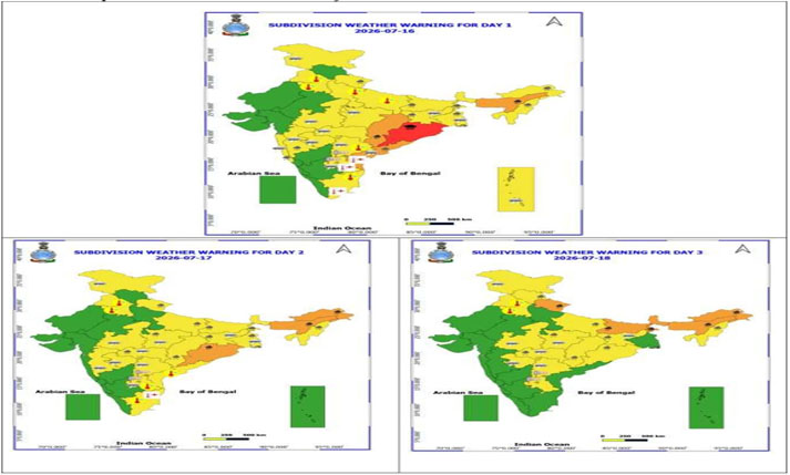

Subject: (i) Under the influence of Well-marked low-pressure area over northwest Bay of Bengal and adjoining north Odisha -West Bengal coasts, enhanced rainfall activity with isolated heavy to very heavy falls over East & Northeast India, East Uttar Pradesh and Western Himalayan Region during next 7 days. Isolated extremely heavy rainfall also likely over Odisha on today, 16th July, 2026.
(ii) Subdued rainfall activity likely to continue over westcentral & south Peninsular India during next 7 days and over plains of northwest India during next 3 days.
Realised weather during past 24 hours ending at 0830 hours IST of today, the 16th July, 2026:
Extremely heavy rainfall (≥21 cm) has been recorded over Odisha.
Very Heavy rainfall (12-20 cm) has been recorded over Arunachal Pradesh, Assam and Bihar.
Heavy rainfall (7-11 cm) has been recorded over East Madhya Pradesh, Chhattisgarh, Konkan, Sub-Himalayan West Bengal, Nagaland and Tripura.
Thunderstorm accompanied with Squally/Gusty winds with speed reaching 60-80 kmph at isolated places over Punjab and Gujarat Region; with speed reaching 40-60 kmph at isolated places over Andaman & Nicobar Islands, Odisha, Bihar, Jharkhand, Haryana, Rajasthan, Madhya Pradesh, Vidarbha, Madhya Maharashtra, Marathawada, Saurashtra & Kutch.
Weather Systems, Forecast and Warnings (Annexure I & II):
The low pressure over Northwest Bay of Bengal and adjoining North Odisha -West Bengal coasts lay as a Well-marked low-pressure area over the same region at 0830 hrs IST of today, 16th July, 2026. It is very likely to move northwestwards across North Odisha & Gangetic West Bengal during next 2 days.
The western end of the Monsoon trough at mean sea level is north its normal position and its eastern end is near its normal position.
The Western Disturbance as a cyclonic circulation lies over Jammu division & neighbourhood in middle tropospheric levels with the trough aloft roughly along Long. 75°E to the north of Lat. 30°N.
An upper air cyclonic circulation lies over north Haryana & neighbourhood in lower tropospheric levels.
An upper air cyclonic circulation lies over East Uttar Pradesh & adjoining Bihar in lower tropospheric levels.
An upper air cyclonic circulation lies over southwest Rajasthan & neighbourhood in lower tropospheric levels.
A trough runs from the cyclonic circulation associated the Well marked low pressure area over Northwest Bay of Bengal and adjoining North Odisha -West Bengal coasts to Eastcentral Arabian Sea in middle tropospheric levels.
A fresh Western Disturbance is likely to affect Northwest India from 19th July, 2026.
Under the influence of above systems, the following weather is likely:
Northwest India:
Isolated to Scattered rainfall likely over Himachal Pradesh and Jammu-Kashmir-Ladakh-Gilgit-Baltistan-Muzaffarabad during 16th-17th July.
Isolated to Scattered rainfall likely over Haryana Chandigarh & Delhi and Punjab during 16th-19th July; West Uttar Pradesh during 16th-18th July; East Uttar Pradesh during 16th-17th July; East Rajasthan and West Rajasthan during 16th-22nd July.
Fairly Widespread to Widespread rainfall likely over Himachal Pradesh and Jammu-Kashmir-Ladakh-Gilgit-Baltistan-Muzaffarabad during 18th-22nd July; Uttarakhand during 16th-22nd July.
Fairly Widespread to Widespread rainfall likely over Haryana Chandigarh & Delhi and Punjab during 20th-22nd July; West Uttar Pradesh during 19th-22nd July; East Uttar Pradesh during 18th-22nd July.
Isolated thunderstorm, lightning & gusty winds (speed reaching 40-50 kmph gusting to 60 kmph) likely over Jammu-Kashmir-Ladakh-Gilgit-Baltistan-Muzaffarabad during 16th-22nd July.
Isolated thunderstorm, lightning & gusty winds (speed reaching 30-40 kmph gusting to 50 kmph) likely over East Rajasthan and West Rajasthan during 20th-22nd July.
Isolated thunderstorm & lightning likely over Himachal Pradesh on 17th July; East Uttar Pradesh and Uttarakhand during 16th-22nd July.
Isolated heavy rainfall likely over Jammu-Kashmir-Ladakh-Gilgit-Baltistan-Muzaffarabad during 19th-20th July and on 22nd July; Himachal Pradesh on 18th July; Uttarakhand during 16th-17th July and on 22nd July; Haryana Chandigarh & Delhi and Punjab during 20th-22nd July; West Uttar Pradesh during 19th-22nd July; East Uttar Pradesh during 17th-18th July and on 22nd July with isolated very heavy rainfall also likely over Jammu-Kashmir-Ladakh-Gilgit-Baltistan-Muzaffarabad on 21st July; Himachal Pradesh during 19th-22nd July; Uttarakhand during 18th-21st July; East Uttar Pradesh during 19th-21st July.
Central India:
Isolated to Scattered rainfall likely over West Madhya Pradesh during 16th-20th July; East Madhya Pradesh on 16th July; Vidarbha during 16th-19th July.
Fairly Widespread to Widespread rainfall likely over West Madhya Pradesh during 21st-22nd July; East Madhya Pradesh during 17th-22nd July; Vidarbha during 20th-22nd July; Chhattisgarh during 16th-22nd July.
Isolated thunderstorm, lightning & gusty winds (speed reaching 40-50 kmph gusting to 60 kmph) likely over East Madhya Pradesh, Vidarbha and West Madhya Pradesh during 16th-20th July.
Isolated thunderstorm & lightning likely over Chhattisgarh during 16th-20th July.
Isolated heavy rainfall likely over Chhattisgarh and East Madhya Pradesh during 17th-21st July; Vidarbha during 17th-18th July with isolated very heavy rainfall also likely over Chhattisgarh on 16th July.
East India:
Isolated to Scattered rainfall likely over Andaman & Nicobar Islands during 16th-20th July; Bihar on 16th July and on 22nd July; Odisha during 19th-22nd July.
Fairly Widespread to Widespread rainfall likely over Andaman & Nicobar Islands during 21st-22nd July; Gangetic West Bengal, Jharkhand and Sub-Himalayan West Bengal & Sikkim during 16th-22nd July; Bihar during 17th-21st July; Odisha during 16th-18th July.
Isolated thunderstorm, lightning & gusty winds (speed reaching 40-50 kmph gusting to 60 kmph) likely over Andaman & Nicobar Islands on 16th July; Gangetic West Bengal during 16th-17th July; Jharkhand during 16th-20th July, with gusty winds (speed reaching 30-40 kmph gusting to 50 kmph) likely over Andaman & Nicobar Islands during 17th-22nd July; Gangetic West Bengal during 18th-20th July; Bihar during 16th-22nd July.
Isolated thunderstorm & lightning likely over Sub-Himalayan West Bengal & Sikkim during 16th-22nd July.
Isolated heavy rainfall likely over Bihar and Sub-Himalayan West Bengal & Sikkim during 16th-17th July and during 21st-22nd July; Gangetic West Bengal during 16th-17th July; Jharkhand during 16th-18th July; Odisha on 16th July and during 18th-20th July with isolated very heavy rainfall also likely over Bihar and Sub-Himalayan West Bengal & Sikkim during 18th-20th July; Odisha on 17th July.
Heavy to very heavy rainfall at few places with extremely heavy rainfall likely at isolated places over Odisha on 16th July.
Northeast India:
Fairly Widespread to Widespread rainfall likely over Arunachal Pradesh during 16th-20th July; Assam & Meghalaya and Nagaland, Manipur, Mizoram & Tripura during 16th-22nd July.
Isolated to Scattered rainfall likely over Arunachal Pradesh during 21st-22nd July.
Isolated thunderstorm & lightning likely over Arunachal Pradesh during 16th-18th July; Assam & Meghalaya and Nagaland, Manipur, Mizoram & Tripura during 16th-20th July.
Isolated heavy rainfall likely over Arunachal Pradesh on 16th July and during 20th-22nd July; Assam & Meghalaya during 20th-22nd July; Nagaland, Manipur, Mizoram & Tripura during 16th-22nd July with isolated very heavy rainfall also likely over Arunachal Pradesh during 17th-19th July; Assam & Meghalaya during 16th-19th July.
West India:
Fairly Widespread to Widespread rainfall likely over Konkan & Goa during 16th-22nd July.
Isolated to Scattered rainfall likely over Gujarat Region, Madhya Maharashtra, Marathawada and Saurashtra & Kutch during 16th-22nd July.
Isolated thunderstorm, lightning & gusty winds (speed reaching 40-50 kmph gusting to 60 kmph) likely over Konkan & Goa on 16th July; Madhya Maharashtra during 16th-17th July; Marathawada during 16th-18th July.
Isolated heavy rainfall likely over Konkan & Goa and Madhya Maharashtra on 16th July.
South Peninsular India:
Isolated to Scattered rainfall likely over Coastal Andhra Pradesh & Yanam, North Interior Karnataka, Rayalaseema, South Interior Karnataka, Tamil Nadu, Puducherry & Karaikal and Telangana during 16th-22nd July; Kerala & Mahe on 16th July and on 22nd July; Lakshadweep during 16th-17th July and on 22nd July; Coastal Karnataka on 16th July.
Fairly Widespread to Widespread rainfall likely over Kerala & Mahe during 17th-21st July; Lakshadweep during 18th-21st July; Coastal Karnataka during 17th-22nd July.
Isolated thunderstorm, lightning & gusty winds (speed reaching 40-50 kmph gusting to 60 kmph) likely over Coastal Andhra Pradesh & Yanam on 16th July; Rayalaseema during 16th-17th July; Telangana during 16th-18th July, with gusty winds (speed reaching 30-40 kmph gusting to 50 kmph) likely over Tamil Nadu, Puducherry & Karaikal during 17th-20th July; Coastal Karnataka, North Interior Karnataka and South Interior Karnataka on 19th July; Rayalaseema during 18th-20th July; Telangana during 19th-20th July.
Isolated thunderstorm & lightning likely over Kerala & Mahe during 16th-17th July; North Interior Karnataka during 17th-18th July; Coastal Andhra Pradesh & Yanam on 17th July.
Isolated heavy rainfall likely over Coastal Andhra Pradesh & Yanam on 16th July.
Strong Surface Winds likely over Coastal Karnataka, North Interior Karnataka and South Interior Karnataka on 19th July; Rayalaseema and Telangana during 16th-20th July.
Heat Wave and Hot & Humid weather conditions warning:
Heat wave conditions very likely in isolated pockets over Coastal Andhra Pradesh & Yanam and Rayalaseema on 16th July; Tamil Nadu, Puducherry & Karaikal during 16th-17th July.
Hot and humid weather conditions likely to prevail over Haryana Chandigarh & Delhi and Punjab during 16th-18th July; East Uttar Pradesh, Telangana and West Uttar Pradesh on 16th July; Tamil Nadu, Puducherry & Karaikal during 16th-17th July; Coastal Andhra Pradesh & Yanam and Rayalaseema on 17th July.
Fishermen Warning:
Fishermen are advised not to venture:
Arabian Sea: Along and off Somalia, Oman, over most parts of west central adjoining some parts of south west Arabian Sea during 16th to 21st July & few parts of northwest Arabian Sea during 16th to 18th July; along and off Gujarat Coast during 18th to 21st July and North Maharashtra Coast during 19th to 20th July.
Bay of Bengal: Along and off Gangetic West Bengal and Odisha coast adjoining most parts of north and few parts of central Bay of Bengal, some parts of south Bay of Bengal and adjoining areas during 16th to 18th July, over Andaman Sea during 16th to 17th July.
Weather conditions and forecast over Delhi/NCR during next 4 days (Annexure III) For more details, kindly refer National Weather Bulletin: https://mausam.imd.gov.in/responsive/all_india_forcast_bulletin.php
For District wise warnings refer: https://mausam.imd.gov.in/responsive/districtWiseWarningGIS.php For Fishermen warning refer https://rsmcnewdelhi.imd.gov.in/fishermenwarning.php
Significant rainfall recorded (in cm) (from 0830 hours IST of yesterday to 0830 hours IST of today):
Odisha: Banki 21;
Assam & Meghalaya: Margherita (dist Tinsukia) 16, Matijuri (dist Hailakandi) 16, Matijuri Arg (dist Hailakandi) 13, Cacher Kvk Aws (dist Cachar) 9, Lakhipur Arg (dist Cachar) 8, Chauldhowaghat (dist Lakhimpur) 8, Chouldhuwaghat Arg (dist Lakhimpur) 8, A P Ghat (dist Cachar) 8, Udaipur (dist Tinsukia) 8, Mawkyrwat (dist South West Khasi Hills) 7, Kokrajhar (dist Kokrajhar) 7, N.lakhimpur/lilabari (dist Lakhimpur) 7, Moranhat (dist Dibrugarh) 7;
Bihar: Mainatand (dist West Champaran) 15, Sikta (dist West Champaran) 13, Khizirsarai (dist Gaya) 5;
Arunachal Pradesh: Itanagar (dist Papumpara) 13, Naharlagun_ Aws (dist Papumpara) 7;
Chhattisgarh: Shankargarh (dist Balrampur) 9, Kusmi (dist Balrampur) 9, Chando (dist Balrampur) 8, Patna (dist Koriya) 6;
Tripura & Nagaland: Kadamtala Arg (dist North Tripura) 11, Jharnapani _aws (dist Dimapur) 7;
East Madhya Pradesh: Ramnagar (dist Maihar) 9, Deori (dist Sagar) 5;
Konkan: Jawhar (dist Palghar) 9, Mokheda – Fmo (dist Palghar) 6;
Sub-Himalayan West Bengal: Buxaduar (dist Alipurduar) 8, Beech Tea Garden (dist Alipurduar) 7, Yuksom (dist Gyalshing)
Gusty winds (in >=40 kmph) (from 0830 hours IST of yesterday to 0830 hours IST of today):
Gujarat Region: Arnej 65;
Punjab: Muktsar – 63; Faridkot – 48; Firozpur – 46; Bhatinda – 46; Fazilka – 39
Andaman & Nicobar Islands: Sri Vijayapuram – 60
Madhya Maharashtra: Kalwan (Nashik) – 57; Shahada (Nandurbar) – 54
Saurashtra & Kutch: Rajkot 56
Haryana: Sirsa – 54; Hisar – 46
Marathwada: Chakur (Latur) – 52; Vaijnath (Beed) – 50
West Uttar Pradesh: Muzaffarnagar (AWS) – 50; Agra (AWS) – 39; Jhansi (AWS) – 39; Lalitpur (AWS) – 39
Bihar: Bikramganj – 48
East Rajasthan: Ajmer – 48
Jharkhand: Ranchi – 46
East Madhya Pradesh: Jabalpur 46, Rewa 41
Vidarbha: Akola – 43; Yavatmal – 39; Wardha – 37; Nagpur – 33; Buldana – 33; Chandrapur – 30
East Uttar Pradesh: Lucknow (AWS Integral University) – 42; Banda (AWS) – 39
Odisha: Mayurbhanj – 41
West Rajasthan: Bikaner – 41; Sri Ganganagar – 37
West Madhya Pradesh: Datia 41.